Hiking in Wrangell is much different than hiking in any of the other National Parks that we have visited. It was very easy to follow the trail while we were in Glacier, Teddy Roosevelt, Voyageurs, Isle Royale and Cuyahoga Valley. It was clearly marked and well traveled—unless, of course, you are purposefully going off trail into the backcountry. Wrangell was much different. You are given a lot more freedom in determining your path thanks to fewer visitors and the immensity of the park. You have two choices in Nabesna, you can go completely and entirely off the beaten path, pick a place and hike to it, or you can take one of their marked trails.
Our first hike involved driving to the end of the road to the Rambler Mine. It is a well-marked trail and you come out of the trees to discover what was, 100 years ago, a fully functioning mine. There is an entrance into the mountain with an ore cart, several buildings and a massive sluice box. A sluice box is used to separate heavier items from lighter items. To simplify the description, gold is much heavier than many other things so you run your dirt down a sluice with a lot of water and the gold will sink to the bottom making it easier to find. We noticed a little bit of a trail up past the sluice and continued around to the side until we saw another mine entrance into the mountain. It was probably 400-600 meters up the hill, so we braved the sprinkling rain and fog to ascend up the mountain further. The trail petered out 200 meters up the hill, but you could see the mine so you just kept hiking until you found your way to the entrance. As hikes go, this was relatively straightforward with a little bit of exploration at the end.

We returned to our car and drove back up the road to another hike called Skookum Volcano. Again a very similar start with an easy-to-follow trail, we crossed a stream and had to follow cairns to navigate our next turn. Cairns are piles of rocks that help mark where you are supposed to go next. They look very unnatural and are thus very easy to pick out. We followed the cairns and the less well travelled trail until we got to the a ridge. We followed the ridge until we got an expansive view out over the Nabesna Road. At the top we were confronted with several options—we could go back the way that we came, or we could just hike down the face of the mountain that we were on and hike across some muskeg to end up back on the road and near our car. We opted for the more exciting route. We descended down a massive scree slope and it felt more like skiing than it did hiking. Trevor hopped down the slope while I donned poles and took a more alpine skiing approach. As we began to descend, the fog and rain rolled in. We got out of the scree, hiked across some talus and then started hitting vegetation. At first it was blueberry bushes and other higher stuff. As the land flattened out it became more and more marshy. The ground was soft and water logged and your feet often sunk in 3-4 inches with every step. There was no trail; the only thing to do was to avoid potholes where you could twist your ankle.
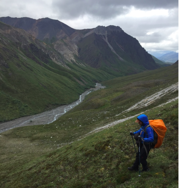
Our third major hike in the area featured the following directions: Hike along the riverbed until it becomes impassable, and then hike up on the ridges. The first 2.5 miles of a hike were along a riverbed. There was no trail, no indication of which way was the best way to go. You just knew to keep following it. The river meandered from left to right and back and forth dozens of times. The water was mostly glacial and snow-fed so you generally wanted to avoid crossing the river, but it was hard to predict when it swing back and forth. We saw a massive red bear skat in the first 5 minutes of our hike (not fresh), so we were less inclined to get out of the riverbed and circle around and river meanderings in the wood. While this part of the hike was only supposed to be 2.5 miles we probably hiked 3-4 miles with all of the back and forth across the river. We finally came to the ‘impassable’ part of the river. The water was basically coming out of a canyon and you couldn’t hike next to it any longer. Up and over we went. We got on the ridge and thought that we found a “trail.” It was not a trail. Often times in Alaska, you will catch game trails. These are commonly used by moose, dear, caribou, bear, or whatever other animals want to trek along the same path. In some instances they can look very similar to hiking trails, because they are quite well worn. They are often clear for sometime and then meander off leaving you to navigate your way through the brush. We crossed the river one last time and found ourselves on the opposite ridge, before deciding that it was time to head back. We returned along a completely different path.
When you are in Alaska the path often doesn’t really matter, as long as you know that you are going in the right direction.
We wanted to see some new land so we hiked back on the opposite side of the river with the intention of dropping back down into the riverbed when necessary. Sometimes it was easy going, there were short scrubby grasses and mosses that were easy to hike through. Other times there were bushes that were knee to chest height that made it slow going.
The two other differences that I would note are animals and berry picking. When you are in Alaska, you have to have your wits about you because the animals that you could run into will mess you up. We were lucky in that we didn’t run into any bears while we were hiking in Nabesna. We did, though, come up and over a ridge and see a massive cow moose. Her senses were incredible. We had just quietly hiked over the hill and she was bounding off into the bushes. She disappeared so quickly that it was impressive. In what seemed like 10 seconds she had trotted 250 meters up a hill and out of sight. The other difference I mentioned was berry picking. We found so many berries that they literally no longer tasted good. They were so abundant in some places that it wasn’t believable. I could have a full handful of blueberries in a matter of 8 seconds. I’m not talking about puny berries either, ripe, plump berries. After about 3 minutes and 24 handfuls of berries they start to lose their appeal, so you keep walking until you can work your appetite up again.
Hiking in Alaska is not for the faint of heart. The terrain is often difficult and the risks can be quite high if you don’t know where you are going, have a bad animal run-in, or are confronted with bad weather. That being said, if you are willing to go for it you will be rewarded with incredible vistas, encounters with massive animals and the world all to yourself.